
Tens of thousands of Californians faced an indefinite stay in shelters as engineers worked for a second day on Tuesday to fix the United States’ tallest dam before more storms sweep the region.
After what looks set to be the wettest winter in northern California following years of drought, more rain was forecast for as early as Wednesday and through Sunday, according to the National Weather Service.
Late on Sunday, about 188,000 residents were ordered to evacuate their homes in the Feather River valley below the Oroville Dam, 105 kilometres north of Sacramento.
Crews working around the clock to make repairs and drain the reservoir behind the dam had made some progress by Tuesday morning, as boulders were brought in my truck and helicopter to shore up the site’s damaged spillway.
‘All we knew is to head north.’
— Evacuee Yolanda Davila
Meanwhile, California Department of Water Resources spokesman Chris Orrock said lake levels are also dropping at a rate of roughly 2.4 metres per day.
The goal is to see the level at 262 metres by Thursday when inflows should begin from the expected storms. Orrock says the lake is currently at 269 metres.
Authorities said earlier they had averted the immediate danger of a catastrophic failure at the dam that could unleash a wall of water three storeys tall on towns below.
“We’re doing everything we can to get this dam in shape that they can return and they can live safely without fear. It’s very difficult,” California Gov. Jerry Brown told reporters during a news conference on Monday evening.
On Monday, Brown sent a letter to U.S. President Donald Trump asking him to issue an emergency declaration, which would open up federal assistance for the affected communities, after an emergency overflow channel appeared on the brink of collapse.
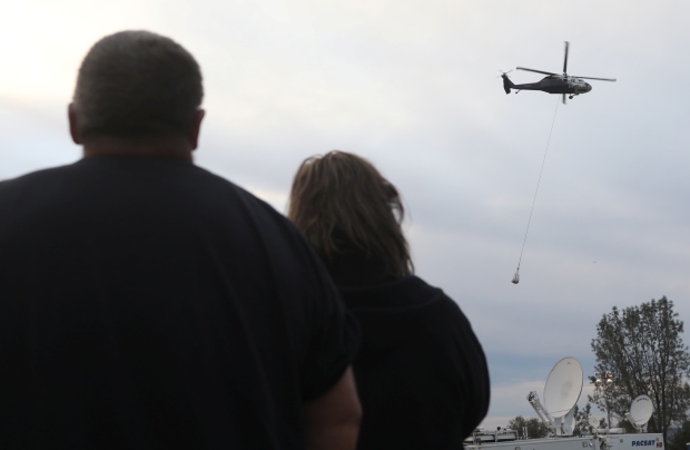
People watch as helicopters haul rock in an effort to repair the Lake Oroville Dam on Monday. (Jim Urquhart/Reuters)
Little warning
Yolanda Davila, 62, of Thermalito, ended up at the Silver Dollar Fairgrounds in Chico, one of only five shelters in the area taking people with pets. She left home without medicine and dog food in the rush to find shelter before the evacuation deadline.
She said that areas such as Sacramento had been issued flood warnings earlier in the week and that authorities should have warned residents near Oroville much sooner.
“We didn’t have a plan, all we knew is to head north toward Chico,” Davila said. “If I knew we had to get out earlier I would have went to the Bay Area.”
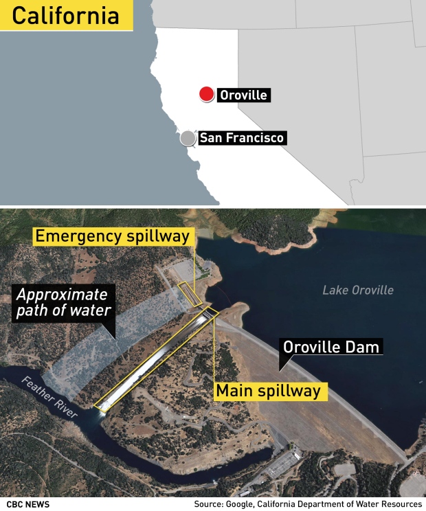
The earth-filled dam is just upstream and east of Oroville, a town of about 16,000 people. At 230 metres high, the structure, built between 1962 and 1968, is some 12 metres taller than the Hoover Dam.
On Monday afternoon, crews dropped large bags filled with rocks into a gap at the top of the emergency spillway to rebuild the eroded hillside.
The main spillway, a separate channel, is also damaged because part of its concrete lining fell apart last week. Both spillways are to the side of the dam itself, which has not been compromised, engineers said.
A consequence of the #OrovilleDam evacuation, nearby town overrun by released or escaped chickens pic.twitter.com/DRoN9VwAGL