
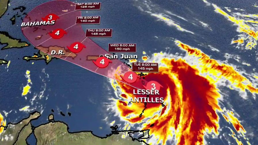
Hurricane Maria strengthened to a Category 5 storm, the National Hurricane Center said on Monday.
As Maria strengthens in the Atlantic Ocean, it threatens Caribbean islands already left devastated by Hurricane Irma a few weeks ago. A hurricane warning has been issued for the U.S. Virgin Islands where many people have been left without food, water or shelter.
Below is what you should know about Maria’s path.
Where is Maria today?
The eye wall of the storm was moving onshore over Dominica, packing 160-mph winds. Forecasters say the hurricane will likely travel over the Leeward Islands and the extreme northeast Caribbean through Monday night and Tuesday.
HURRICANE WARNING VS. WATCH: HOW ARE THEY DIFFERENT?
What else should I know about the hurricane?
There’s a hurricane warning for Guadeloupe, Dominica, St. Kitts, Nevis, Montserrat, Martinique, the U.S. Virgin Islands, the British Virgin Islands, Puerto Rico, Culebra and Vincennes. Other areas in the Caribbean are under hurricane watches, including St. Martin and St. Barthelemy.
“A warning means that hurricane conditions are expected whereas a watch means that conditions are possible,” according to the National Oceanic and Atmospheric Administration’s National Ocean Service.
WHAT IS THE SAFFIR-SIMPSON SCALE?
Saint John and Saint Thomas — two islands part of the U.S. Virgin Islands — were left ravaged and devastated from Hurricane Irma a few weeks ago. The islands, especially Saint John, lack basic necessities and shelter, and some residents have been unable to evacuate ahead of Maria, they told Fox News.
“Dangerous” storm surges and large waves can raise water levels up to nine feet above normal tide levels, the National Hurricane Center warned Monday.
The Associated Press contributed to this report.