

Forecasters issued flash flood warnings Monday throughout the San Francisco Bay Area and elsewhere in northern California as downpours swelled creeks and rivers in the already soggy region.
The National Weather Service said heavy rain could persist into the evening and was expected to cause flooding on the Carmel River in Monterey County and Coyote Creek in Santa Clara County.
In the San Joaquin Valley, residents were patrolling levees for signs of danger, reviewing evacuation plans and filling hundreds of sandbags as the San Joaquin River kept rising.
“Our community is pulling together like real champs,” said San Joaquin River Club resident Paula Martin, who is helping co-ordinate emergency plans for the private neighbourhood of 800 homes.
Martin said the neighbourhood has sirens in a clubhouse and church that can warn residents of impending flooding.
The weather service issued snow and wind advisories, including a flash flood warning for the Soberanes burn area in Monterey County. It said winds could reach 97 km/h in the San Francisco Bay Area.
Santa Cruz County had seven centimetres of rain in 24 hours and could get up to 20 centimetres before the storm passes Tuesday. Marin County got six centimetres of rain while 2.5 centimetres fell in San Francisco.
Forecasters said rainfall in San Francisco has already surpassed the normal annual amount for the wet season that begins in October.
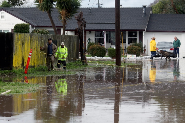
Continued rain in northern California has swelled creeks and rivers in the already soggy region. (Nic Coury/Monterey County Weekly/Associated Press)
The city has logged 62 centimetres of rain since Oct. 1, said forecaster Bob Benjamin. The average rainfall for the year ending Sept. 30 is 60 centimetres.
A pre-evacuation advisory was issued for a community in Madera County after water discharges from Bass Lake were increased and threatened to swell rivers, officials said.
The Fresno Bee reported that the order was issued for several roads near downtown North Fork, about 16 kilometres from the lake.
The sheriff’s office said residents should be ready to leave quickly if conditions worsen.
1.5 metres of snow possible
In the mountains, the weather service forecast heavy snow in the Lake Tahoe area with a high avalanche danger until Tuesday in an area of the Sierra Nevada from Yuba Pass to Ebbetts Pass.
Forecasters said the winter storm could drop up to 1.5 metres of snow in areas above 2,300 metres, while lower elevations could see between 20 and 60 centimetres of snow.
Forecasters advised motorists to avoid travel in the area through Tuesday.
Moderate to heavy rain along with snowmelt below 2,000 metres was expected to swell rivers and streams and increase the chance of flooding.
Levees at risk
The San Joaquin River was approaching the top of levees and could remain at that level for four days, said Tim Daly, a spokesman with the San Joaquin County Office of Emergency Services.
“When the water gets that high and more water is coming, there is just too much pressure and levees can break,” Daly said. “They can be topped.”
The Don Pedro reservoir, which captures water from the Tuolumne River, a key tributary of the San Joaquin, was at 97 per cent capacity.
The weather service also issued flash flood warnings for the North Bay and Monterey areas as well as south-central Alameda County and southeastern Santa Clara County.
In Alameda County, the weather service reported gauges on Alameda Creek were showing that rapidly rising water levels have surpassed local flood stages in Niles Canyon and a watershed above Sunol Regional Wilderness.
For the first time in more than 10 years, water flowed into Lake Berryessa’s unique spillway.
The Monticello Dam Morning Glory Spillway, also known as the Glory Hole, operates similarly to a bathtub drain for the northern California lake.
The last time it spilled over was in 2006.
Elsewhere, the water level kept falling at Oroville Dam, where a damaged spillway had raised major flood concerns and forced 188,000 to leave their homes a week ago.